
Page 184 - Start Up Mathematics_5
P. 184
Learning Beyond
Maps
A map depicts the location of an object or place in relation to other objects or places. With
the help of maps, we can also see how small or big places are in comparison to other places.
Scale
A map has a fixed scale which shows how much actual distance is denoted by 1 mm or
1 cm in the map. For example, 1 cm = 10 km means that a distance of 1 cm on the map is
equivalent to an actual distance of 10 km. Scale can vary from map to map but not within
a map.
N
Directions
NW NE
A map indicates directions to locate places correctly. There are
four main directions—north (N), south (S), east (E) and west (W). W E
The intermediate directions are northeast, northwest, southeast
and southwest. SW SE
Key S
A map uses different symbols for different landmarks. Key tells us the meaning of the different
symbols used in the map.
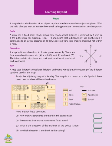
1. Study the adjoining map of a locality. This map is not drawn to scale. Symbols have
been used to show different landmarks.
N
+ Key
Park Entrance
+ Clinic Apartments
` Bank School
Police Station
`
Now, answer these questions.
(a) How many apartments are there in the given map?
(b) Entrance to how many apartments faces north?
(c) What is the direction of the entrance of the police station?
(d) In which direction is the bank in the colony?
1 17676